Southern New Mexico is basin-and-range country — elongated mountain blocks separated by sediment-filled valleys, each basin largely hydrologically isolated from the next. That isolation matters for foundations because it means the soil chemistry and moisture history of each basin is distinct. What the Mesilla Basin does to foundations is not what the Tularosa Basin does, even though they are geographically close.
The common thread across this region is collapsibility. Many of the alluvial soils in southern New Mexico are dry-deposited and have never been saturated. They support load under dry conditions and consolidate under first wetting. A century of irrigation agriculture in the Mesilla Valley has triggered that process in many mid-century foundations. In the Jornada del Muerto and Lordsburg Basin, the first-wetting event has not happened yet for many structures — it is still ahead of them.
Southern New Mexico soils have often been dry for so long that no one thinks of them as a risk. The risk is there. It activates when moisture arrives for the first time.
Back to the New Mexico Soil Roadmap →
Not sure what you're seeing? See our Symptom Guide →
For the full range of causes, see Why Foundations Move →
Five basins. Five soil stories.
Select a basin to read field observations, hazard profiles, and the communities we serve within it.
The lower Rio Grande valley — irrigated for over a century, with lake sediments buried beneath the surface and a collapsible upper soil layer that most people do not know is there.
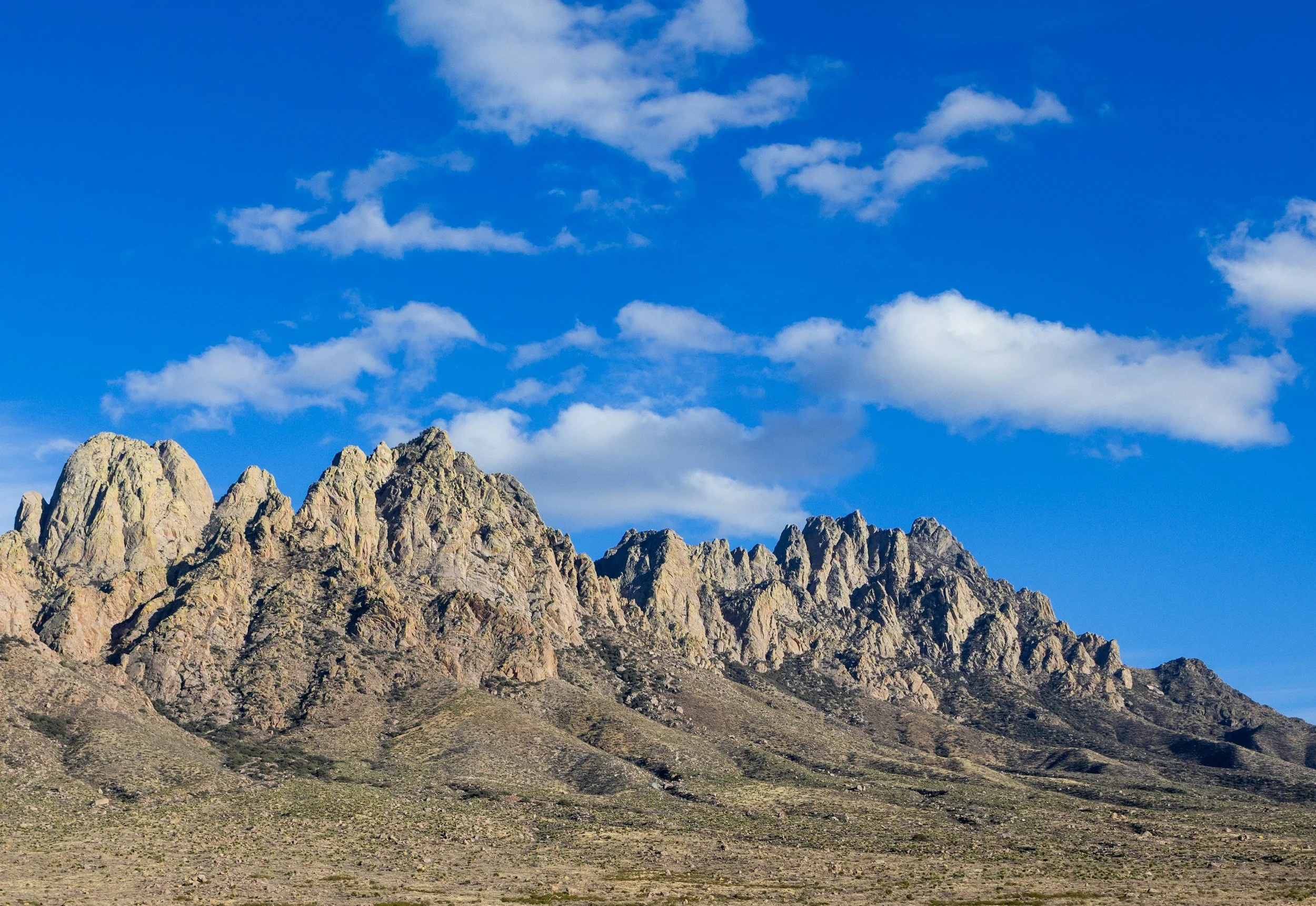
The Mesilla Valley is greener than you expect for the Chihuahuan Desert — the Rio Grande and a century of irrigation agriculture have changed the landscape. The soil at grade is often a light tan to brown silt loam that looks and feels like decent ground. Driving into Las Cruces from the north on I-25, the La Mesa surface — an old alluvial terrace — stretches to the east. That surface soil is collapsible. Closer to the river, the soils are heavier and wetter from irrigation history. The Organ Mountains to the east are bedrock — a dramatic transition from the valley soils within a few miles.
The La Mesa surface soils are collapsible — dry, they support load; wet, they consolidate. Irrigation, landscape watering, and the general moisture increase that comes with urban development have triggered first-wetting collapse in many Las Cruces foundations built in the mid-20th century expansion. Below the upper collapsible layer, Fort Hancock Formation lacustrine clays are present in the deeper subsurface. These are expansive. The combination — collapsible upper soils over expansive deeper clays — means the hazard depends on how deep the moisture penetration goes. Shallow wetting triggers settlement. Deep wetting triggers heave.
Collapsible La Mesa surface soils — Dry-deposited collapsible alluvium on the La Mesa terrace surface. Irrigation, landscape watering, and urban development moisture have triggered first-wetting collapse in many mid-20th century Las Cruces foundations. The movement is rapid relative to the decades of stability that preceded it.
Fort Hancock lacustrine clays at depth — Below the upper collapsible layer, lacustrine clays are expansive. The hazard depends on how deep moisture penetration goes — shallow wetting triggers collapse, deep wetting triggers expansion. Two mechanisms, same foundation, different depths.
Century of irrigation moisture — The Mesilla Valley has been irrigated for over 100 years. Soils that were dry at construction have been repeatedly wetted and dried. Moisture migration from irrigation history shapes what we find beneath these foundations — the soil is not in its natural state.
Las Cruces · Mesilla · Doña Ana · Anthony · Sunland Park · Fairacres · Mesilla Park · La Mesa · Radium Springs · San Miguel · Berino · Chamberino · La Union · Vado · Mesquite · Desert · Organ
A narrow strip of Rio Grande floodplain between the Mesilla Basin and the Jornada del Muerto — chile country with variable soils that shift within a single lot.
Hatch is known for its chiles and sits in a narrow stretch of the Rio Grande valley where the canyon pinches in from both sides. The soils in the active floodplain and the old terrace surfaces vary within short distances — river-deposited sandy material next to heavier overbank clays, sometimes with abandoned channel fills that are softer than the surrounding ground. The terrain is flat, which makes it harder to read soil character from the surface. You need to get into the ground to understand what you have.
Lateral variability is the primary challenge in this corridor. Overbank clay deposits are expansive; sandy channel deposits are loose and compress under load. A single structure can span both soil types, producing differential movement that is difficult to predict from surface observation alone. Irrigation agriculture in the valley has raised the local water table historically in some areas, adding seasonal moisture to soils that would otherwise be dry.
Lateral soil variability — Expansive overbank clays adjacent to loose sandy channel deposits, sometimes within the same foundation footprint. Lateral variability is the defining characteristic of this corridor — two soil types with opposite behavior under moisture, separated by feet rather than miles.
Expansive overbank clays — Expansive clay in the overbank deposits responds to irrigation and seasonal moisture with heave. The valley floor has been wet long enough that the clay is in an active expansion-contraction cycle.
Loose channel fill compression — Sandy abandoned channel deposits compress under load. Where a foundation spans both overbank clay and channel fill, differential movement is the predictable outcome — one side heaves, the other settles.
Hatch · Rincon · Radium Springs · Garfield · Arrey · Derry · Monticello
A closed basin filled with gypsum — White Sands is the most visible expression of it, but the same chemistry that built those dunes is present in the subsurface under every foundation in this valley.
Driving into Alamogordo from the north or south, the white gypsum of White Sands National Park is visible on the horizon. The soil near the basin floor is pale — sometimes almost white — from gypsum and calcium carbonate. Playas at the lowest elevations are perfectly flat, with cracked clay surfaces that tell you about the wet and dry cycles. The Sacramento Mountains rise abruptly to the east, and the alluvial fans coming off those mountains deliver coarser material that grades down to fine-grained basin floor deposits.
Gypsum in the subsurface dissolves under sustained moisture — slowly, but measurably over the life of a structure. Dissolution creates voids that can cause sudden or gradual foundation settlement without obvious surface warning. Sulfate in the soil and groundwater attacks concrete chemically over time, degrading foundation material independent of movement. Sulfate heave is a secondary hazard. The playa lake clays are highly expansive. The closed basin hydrology means any moisture introduced by development or irrigation has nowhere to go — it stays in the soil and amplifies both mechanisms.
Gypsum dissolution — Gypsum in the subsurface dissolves under sustained moisture, creating voids beneath foundations with no surface warning. The closed basin hydrology means any moisture introduced by development stays in the soil — it has nowhere to go. Dissolution accelerates with urban moisture.
Expansive playa clays — Playa lake clays at the basin floor are highly expansive. Closed basin hydrology amplifies the wet-dry cycles — moisture introduced at the surface concentrates rather than dispersing.
Sulfate attack on concrete — Sulfate in the soil and groundwater attacks concrete chemically over time. Sulfate heave — a chemical reaction between sulfates and calcium in concrete — is a secondary hazard throughout the basin, independent of soil movement.
Alamogordo · Tularosa · La Luz · Holloman AFB · Desert Lakes · Orogrande · Chaparral · Three Rivers · Bent · Mescalero
Permian limestone country at elevation — the rock is close to the surface, the frost is deep, and the differential bearing between soil and rock under the same foundation is the hazard most people miss.
Cloudcroft sits at 8,650 feet — the highest community in southern New Mexico. The drive up from Alamogordo gains 4,500 feet in 16 miles, and the soil character changes completely. At elevation, the limestone bedrock is close to or at the surface in many areas. The soil cover is thin — a few inches to a few feet — and the rock underneath it varies in depth across a small area. In Ruidoso, the canyon terrain means lots of cut-and-fill construction, which creates its own foundation challenges independent of the natural geology.
Shallow rock with variable depth is a differential bearing problem — one part of a foundation is bearing on rock, another part is bearing on soil, and they respond differently to load. At Cloudcroft elevations, frost penetrates 36 inches or more, and footings that do not reach below the frost line will heave seasonally. Ruidoso's cut-and-fill construction means some structures are bearing on engineered fill that has not been compacted to the standard needed for a foundation — we see this regularly in the canyon area developments built during the growth years.
Differential bearing — rock and soil under the same foundation — Shallow Permian limestone at variable depth means different parts of the same foundation can bear on rock and soil simultaneously. Differential movement is the predictable outcome. Bearing capacity varies dramatically within a single footprint.
Frost heave at elevation — At Cloudcroft and higher elevations, frost penetrates 36 inches or more. Footings that do not reach below the frost line heave every winter. Combined with variable rock depth, the seasonal movement can be significant.
Cut-and-fill construction — Ruidoso canyon developments — Canyon terrain means cut-and-fill construction is the rule in Ruidoso. Fill placed without adequate compaction testing settles under load — we see this regularly in developments built during the growth years. The fill side settles while the cut side stays put.
Ruidoso · Ruidoso Downs · Cloudcroft · Alto · Capitan · Carrizozo · High Rolls · Mountain Park · Sunspot · Pinon · Weed · Lincoln · Nogal · Glencoe · Hondo · Tinnie · White Oaks · Corona · Jicarilla
The dead man's route — a basin named for the difficulty of crossing it, where collapsible soils wait for the first sustained wetting event that most structures have never experienced.
The Jornada del Muerto is an elongated basin between the San Andres and Oscura ranges to the east and the Rio Grande valley to the west. It is sparse country — ranches, small communities, Socorro to the north, Truth or Consequences to the south. The soil is pale alluvium, dry, with a surface that looks like it has never held water. That appearance is accurate for most of its history. The problem is when development introduces moisture into soil that has never been consistently wet.
Classic collapsible soil territory. The alluvial soils of the Jornada are dry-deposited and have never been saturated — they have an open, loose structure that supports load under dry conditions. The first sustained wetting event — a broken irrigation line, landscape watering for a new yard, an unusually wet year — can cause sudden consolidation. Settlement that took decades elsewhere can happen in a season here. Truth or Consequences sits on Jornada-character soils with the added complexity of geothermal influences from the hot springs that define the community.
Collapsible alluvial soils — first wetting trigger — The Jornada del Muerto alluvial soils have never been saturated. They carry load under dry conditions and consolidate under first wetting. Hydrocompaction can be rapid — movement that accumulated over decades elsewhere can happen in a season here.
Development moisture as trigger — Structures on native soil that have never been irrigated are at greatest risk when site conditions change. Landscape watering for a new yard, an irrigation system, a broken line — any sustained moisture introduction can trigger the collapse mechanism. Moisture migration is the activation event.
Truth or Consequences geothermal complexity — T or C sits on Jornada-character soils with the added complexity of geothermal influences from the hot springs. Subsurface thermal and moisture conditions are different from the surrounding basin. Evaluation in T or C requires accounting for both collapsible soil hazard and geothermal influence.
Socorro · Truth or Consequences · Williamsburg · Elephant Butte · Magdalena · Bernardo · Escondida · La Joya · Lemitar · Luis Lopez · Polvadera · San Acacia · San Antonio · Veguita · Arrey · Caballo · Cuchillo · Winston · Hillsboro · Las Palomas · Placitas · Monticello · Reserve · Quemado · Pie Town · Datil · Glenwood · Luna